Marco Island National WX Service Weather
Current Gulf Coast FL Temperatures & WX Forecasts
 Few places in the United States enjoy weather as warm, sunny, and consistently inviting as Marco Island, Florida. Nestled along the stunning Gulf Coast in Collier County, Marco Island sits at the gateway to the Ten Thousand Islands and the edge of the Everglades — a region known for year-round sunshine, gentle breezes, and vibrant subtropical beauty.
For travelers planning a visit, Marco Island’s weather is more than a backdrop; it’s part of the island’s character. The sound of palm fronds rustling, the scent of salt in the air, and the sight of a crimson Gulf sunset — these are daily gifts shaped by the island’s unique climate.
Bookmark this page for Marco Island and Southwest Florida weather updates, travel tips, and seasonal insights for planning your next visit to this tropical paradise.
To feature your business, contact us.
Marco Island Weather
Florida Weather Alerts from the National Weather Services
- Coastal Flood Advisory issued October 31 at 10:30AM EDT until October 31 at 5:00PM EDT by NWS Key West FL
- Coastal Flood Statement issued October 31 at 10:30AM EDT until October 31 at 5:00PM EDT by NWS Key West FL
- Rip Current Statement issued October 31 at 10:02AM EDT until October 31 at 8:00PM EDT by NWS Miami FL
- Flood Warning issued October 31 at 9:20AM EDT by NWS Melbourne FL
Marco Island Weather – What to Expect When Visiting Southwest Florida
Few destinations capture the sun-soaked charm of Florida’s Gulf Coast quite like Marco Island. Nestled in the heart of Southwest Florida, this barrier island is a paradise of white-sand beaches, warm breezes, and endless blue skies. For visitors, Marco Island weather is not just a backdrop—it’s the main attraction. The island’s mild winters, balmy summers, and dramatic tropical skies create a rhythm of life that feels perpetually tied to the sea.
Whether you’re planning a winter escape or a late-summer adventure, understanding the island’s unique weather patterns can help you make the most of every sunrise and sunset.
The Allure of Marco Island’s Climate
One of the greatest appeals of visiting Marco Island is its predictably pleasant weather. The Gulf waters stay warm for much of the year, and the region enjoys an abundance of sunshine—more than 260 days annually. Even when afternoon rain showers sweep through, they tend to move on quickly, leaving behind dazzling rainbows and that distinct, sweet scent of the tropics.
Winter in Marco Island is the envy of much of the country. When much of the United States is bundled up in coats and scarves, Marco Island is basking in warmth. From December through March, temperatures often climb into the upper 70s and low 80s, making it one of the warmest winter destinations in the nation. The air is dry, the skies are bright, and the evenings are comfortably cool.
Locals often say that Marco Island enjoys two seasons: the Dry Season and the Green Season. Each has its own charm and beauty.
WEATHER INSTRUMENTS
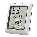
- 【Air Comfort Indicator】Humidity meter with humidity level icon indicates air condition -- DRY/COMFORT/WET, allowing this humidity sensor to ensure you’re always aware of changes to your home/household with just a quick glance
- 【High Accuracy and Quickly Refresh】Inside thermometer has high accuracy of ±2~3%RH and ±1°F, making it ideal for measuring fluctuating readings like in a greenhouse; Data measurements are updated every 10 seconds to give you lastest changes of the environment
- 【High & Low Records】Accurate hygrometer digital thermometer displays high and low temperature & humidity, always get ready to the changes of the environment
- 【Healthier Home & Environment】Thermometer hygrometer with temperature and humidity monitor ensures proper indoor humidity control has important skin, allergen and other health benefits; Can also be as refrigerator thermometer, freezer thermometer, reptile thermometer, soil thermometer, humidor hygrometer, cigar hygrometer and more
- 【Smart Design】Indoor room thermometer features a tabletop stand to place the temperature monitor on your counter or use the magnetic back to attach to a fridge; °F/°C Selector; Powered by 1 x AAA battery (included)
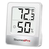
- Face Icon Comfort Indicator: Humidity temperature gauge features face icons to indicate DRY/COMFORT/WET air conditions, quickly informs you how to adjust your humidifier or dehumidifier to achieve optimal comfort
- Highly Accurate Sensors: This temperature humidity sensor features a high accuracy of +/-1°F/°C and +/-2% to 3%RH, making it ideal for measuring dynamic environments like greenhouses
- Fast Refresh Rate: This digital indoor thermometer refreshes every 10 seconds to provide the latest updates for temperature and humidity readings
- Compact Display with Large Digits: This digital thermometer indoor outdoor features a compact LCD display with large bold digits, allowing you to read the room thermometer indoor from any angle and distance
- Multiple Placement Options: This humidistat has 3 placement options - Tabletop Stand / Magnetic Back / Hanging Mount, place the wall thermometer anywhere you wish such as living room, baby room, kitchen, greenhouse, guitar room, office or cellar

- Please Note: This product must be powered by a 12V DC Cigarette Lighter to function properly, and ensure the vehicle is in a running state. And it equipped with a 9.8-foot cord, which can meet the usage needs of most regular-sized vehicles.
- PROGRAMMABLE INFLATION: Use the "M" button to set your desired pressure unit, and then press the "+" and "-" buttons to set the desired pressure. The air compressor will automatically shut off when it reaches the pre-set pressure (Please make sure the pressure you set is higher than the current pressure of your tire).
- COMPACT SIZE & EASY TO STORE: Featuring a lightweight and compact design, this handy and portable tire inflator can easily fit into glove compartments, seats, trunks, and more. When it isn’t being used, it’s almost unnoticeable.
- SMART PRESET & AUTO OFF: The tire inflator’s digital screen provides accurate readouts and 4 pressure units to choose from while its independent buttons allow for intuitive control. You can easily preset the tire pressure and not worry about constantly monitoring it, this smart inflator will automatically shut off once it reaches the desired pressure.
- EASY NIGHTTIME USE: Equipped with a backlit screen and a flashlight, this tire inflator brings convenient use, even in dim environments. Its independent LED Button enables one-press flashlight operation. Great gifts for men and women.
- TOUGHULTRA TECHNOLOGY, ENHANCED DURABILITY: This tire inflator is manufactured with AstroAI’s unique ToughUltra technology, so all of its core parts, including its cylinder, motor gears, and connection rod, are built using a powder metallurgy integrated molding technique. This revolutionary manufacturing process greatly enhances the inflator’s durability and increases its service life by 50%.

- Everything you need in a garage door lubricant: High performance and fast drying. Select a wide or narrow spray for fast, easy application
- Lubricate and protect metal between moving parts on garage doors to keep them moving and free from corrosion
- Quick drying, non-sticky application ensures your parts don't attract dirt and other contaminants over time
- Professional grade formula designed to keep even the heavy duty commercial garage doors operating smoothly
- Use on all moving parts of a garage door - hinges, tracks, chains, pulleys, rollers, and more

- LASTS ALL YEAR. GUARANTEED! Guarantee is valid for one year from purchase or delivery date, whichever is longer. Does not cover misuse.
- Scan, study and organize your notes with the Five Star Study App. Create instant flashcards and sync your notes to Google Drive to access them anywhere from any device.
- This 5 subject notebook has 200 double-sided, college ruled sheets that fight ink bleed and are perforated for easy tear out. Sheets measure 8-1/2" x 11" when torn out.
- Tough pockets help prevent tears and hold 8-1/2" x 11" loose sheets. Durable plastic front cover is water resistant to help protect your notes and our Spiral Lock wire helps prevent snags on clothes and backpacks.
- Made with SFI certified paper. Notebook is recyclable – just remove the reinforcement tape on the pocket and recycle the rest! Available in Black.
Lodging | Dining | Real Estate | Attractions
Contact Us | Marco Island Living Store
Marco Island Weddings

JW Marriott Rates & Availabilities
Fun | Dining | Eco Tours | Fishing
Real Estate | Rentals
Resorts | Pet Friendly Rooms & Suites